Recreation
Katy Trail State Park
With over 400 feet of frontage on the Katy Trail State Park , the longest developed rail-trail in the country, you’ll have private access to over 240 miles of trail. Great for walking, running, and biking, the trail provides ready access to nearby wineries, restaurants, and other parks in the Defiance and Augusta. Venture further afield, and you can use the Katy trail to ride to old town St Charles, Chesterfield Valley, Washington, Missouri, and beyond.
Bicycling
Use the Katy Trail as a means to bike to local points of interest including:
| Distance | Point of Interest |
|---|---|
| 1 mile | Defiance Ridge Vineyards , Good News Brewery , and taverns |
| 5 miles | I-64/Highway 40 Boone Bridge and bike access to Chesterfield Valley including the levee bike trail |
| 6 miles | Klondike Park |
| 10 miles | The District restaurants and outdoor venue in Chesterfield Valley via the I-64/Highway 40 Boone Bridge |
| 10 miles | Augusta wineries and restaurants |
| 18 miles | Washington, MO restaurants and shops |
| 19 miles | Old town St Charles, MO restaurants and shops |
Road cycling
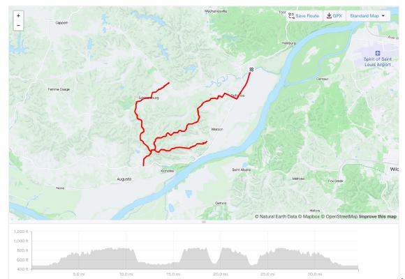
If you like road cycling, use the Katy trail to connect to local roads behind and above Defiance. One route includes a 34-mile ride out to the tiny hamlet of Schluersburg and back. You can get in 3,600 feet of climbing on 30 MPH lightly trafficed roads without getting on any 55 MPH highways.
Gravel biking
If you’re into gravel biking, you’ll have easy access to the nearby 5-mile scenic gravel Callaway Fork road, the Hamburg trail, and miles of gravel in the Busch Wildlife area. You can use the Katy Trail to access these popuklar gravel rides.
Mountain biking
The Katy Trail oiffers easy access to the following popular mountain biking trails:
- 1 mile to Lost Valley Trail
- 2 miles to Matson Hill Park ( map )
- 6 miles to Klondike Park ( map )
Running
The crushed rock surface and scenery of the Katy Trail offer a great running experience. If you’re into single track trail running, you can use the Katy Trail to access the nearby Lost Valley (1 mile via the Katy) and Lewis and Clark (4 miles via the Katy) trail systems.
Hiking
Offering 5- and 8-mile options, the Lewis and Clark hiking trail is just either a 5-minute drive or a 20-minute bike ride on the Katy Trail.
The 11-mile Lost Valley Trail is just 1 mile away via the Katy Trail.
Femme Osage Creek and Missouri River access
Use your private dock on over 260 feet of the Femme Osage Creek to set off on paddle boarding, kayaking, canoeing, and fishing adventures. You’ll have 1.75 miles of secluded floating down the Femme Osage prior to the confluence with the Missouri River. There are no other homes and structures in use on the creek between this home and the Missouri River.
Paddle boarding and canoeing
During spring, summer, and early fall, you can typically paddle board for more than a mile from the home downstream toward the Missouri River. Canoeing is typically available year round.
Fishing and boating
The home’s Femme Osage Creek shoreline and private dock offer access to a wide variety of fish species and at least ~2 miles of length for fishing. Via the creek, you also have access to the Missouri River. If you’re into boating on the river, you could conceivably establish a basic boat ramp on the property to enable access to the creek and the river.
River and creek water levels
Winter is typically the low water season for the Femme Osage Creek. During winter, springs feed the creek and ensure that there’s a minimum water level. At a minimum water level, the creek is usable for fishing and canoeing downstream toward the Missouri River.
As spring arrives and snowmelt and rain occur in the upper Missouri River basin, the river level rises and typically begins to back up into the creek. We call the resulting rise of the creek the backwater state of the creek. A certain levels of backwater, you can paddle a canoe or paddleboard all the way from the home to the river 1.75 miles away. At higher backwater levels, john boats are able to navigate from the river all the way up the creek and even past the home.
The National Weather Service (NWS) has a river water level and flow monitoring station at Washington MO . By monitoring the Washington gauge, you can get a good idea of the impact to the water level of the Femme Osage Creek.
Historical river and creek levels
To give you an idea of how the creek water levels change over a typical year and across years, the following graph shows river water levels at Washington for the past 16 years along with key river water levels that enable certain activies and distances along the creek.


